 ™

About River Flow Planner
River Flow Planner turns decades of historical daily streamflow and reservoir records into practical planning tools. It covers publicly available gages operated by the U.S. Geological Survey, the U.S. Bureau of Reclamation, and other state and federal Water Resource agencies.
For each gage you can see a summary hydrograph of typical flows through the year, the percent of time flows fall within a range you choose, the likely range of flows on future dates, how a recent period compares with normal, and (for USGS gages with peak-flow records) flood frequency statistics, with CSV downloads and links to current real-time data and short term forecasts. Anglers, rafters, kayakers, swimmers, irrigators, engineers, hydrologists, and anyone planning in-stream work can use it to choose dates when flows are most likely to suit their needs.
Browse gages by basin: Deschutes River Basin · Goose & Summer Lakes Basin · Grande Ronde River Basin · Hood River Basin · John Day River Basin · Klamath River Basin · Malheur Lake Basin · Malheur River Basin · Mid Coast Basin · North Coast Basin · Owyhee River Basin · Powder River Basin · Rogue River Basin · Sandy River Basin · South Coast Basin · Umatilla River Basin · Umpqua River Basin · Willamette River Basin
Find a gage
Choose a state, then a river drainage basin, then a gage name or gage number, and open its River Flow Planner file.
Basin map
A shaded-relief map of the Rogue River drainage basin (with Lower, Middle, and Upper Rogue sub-basins, the Illinois River, Applegate River, and Bear Creek watersheds outlined), with gage markers plotted from each gage’s recorded latitude and longitude. Click or tap any marker to open that gage’s River Flow Planner file.
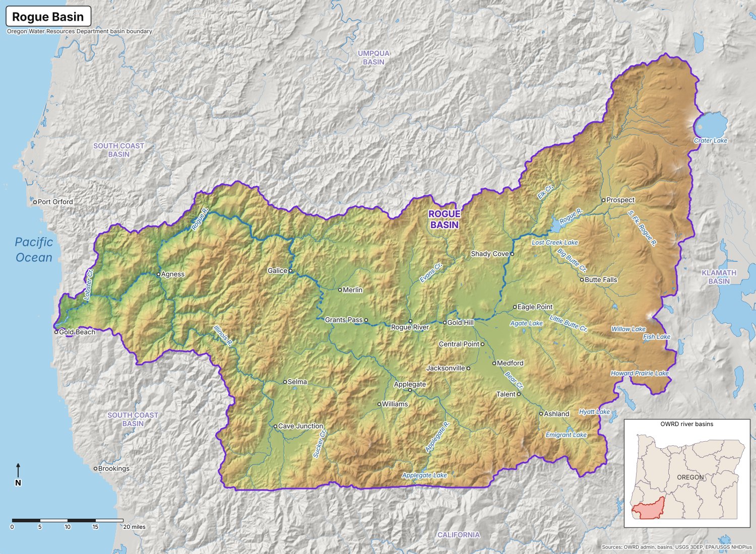
Scroll or use the +/− buttons to zoom in on the map, then click and drag to pan around. Where markers overlap, clicking shows a list of the gages at that spot.
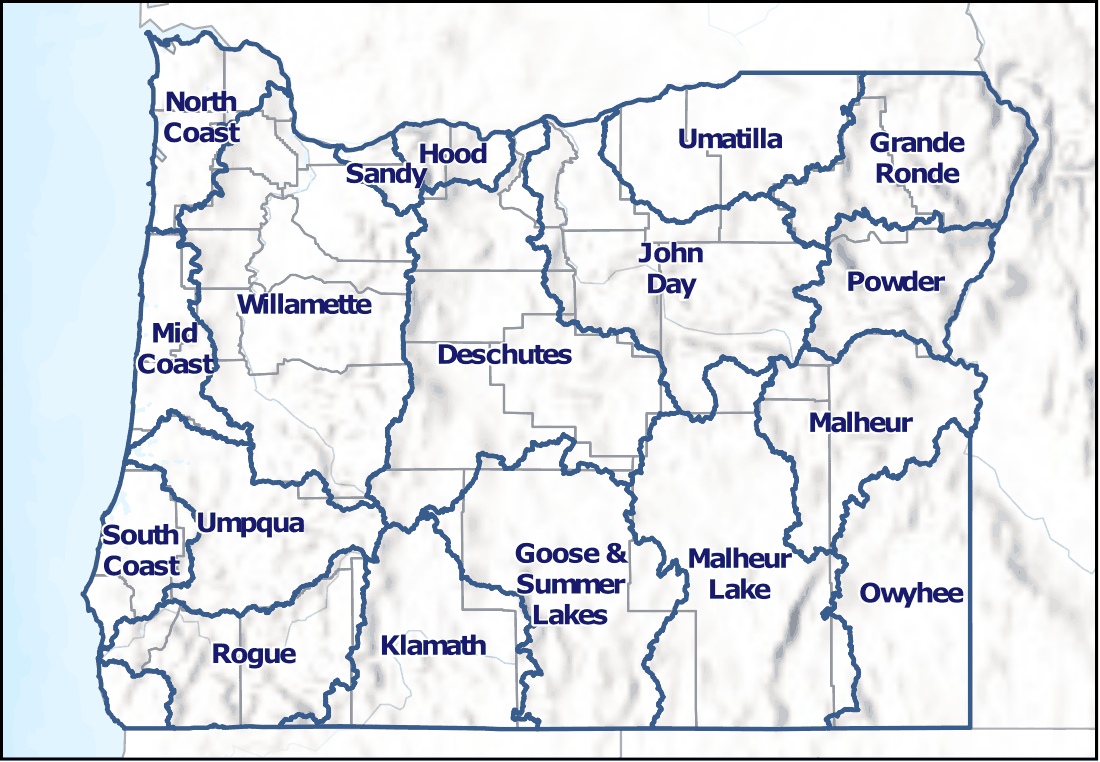
Oregon River Basins
Statewide reference map showing Oregon’s official river drainage basins (Oregon Water Resources Department), shown for geographic context alongside the river drainage basin map above.
Gage Locations Covered
River Flow Planner currently covers 612 river and reservoir gages in Oregon and northern California: the Rogue River basin (61 gages), the Klamath River basin including the Williamson, Sprague, Lost, Shasta, Scott, Salmon and Trinity rivers (71 gages), the Deschutes basin including the Crooked, Metolius, Little Deschutes, Warm Springs and White rivers, Whychus and Tumalo creeks, Wickiup, Crane Prairie and Prineville reservoirs and Lake Billy Chinook (74), the North Coast basin including the Necanicum, Nehalem, Miami, Wilson, Trask and Nestucca rivers (15), the Mid Coast basin including the Salmon, Siletz, Yaquina, Alsea, Yachats and Siuslaw rivers (15), the Umpqua basin including the North Umpqua, South Umpqua, Cow Creek and Calapooya Creek (38), the South Coast basin including the Coos, Coquille, Sixes, Elk, Chetco and Winchuck rivers (17), the Willamette basin including the Middle Fork, Coast Fork, McKenzie, Santiam, Yamhill, Molalla, Pudding, Tualatin and Clackamas rivers and the Willamette Valley Project reservoirs (155), the Sandy basin including the Salmon, Little Sandy and Bull Run rivers and the Bull Run reservoirs (18), the Hood basin including the Hood River, Mosier Creek, Fifteenmile and Eightmile creeks and the Columbia River at The Dalles (13), the John Day basin including the North, Middle and South forks of the John Day River (16), the Umatilla basin including the Umatilla and Walla Walla rivers, McKay, Birch, Butter and Willow creeks, McKay and Cold Springs reservoirs and Willow Creek Lake (45), the Grande Ronde basin including the Grande Ronde, Wallowa, Lostine and Minam rivers, Catherine Creek, Wallowa Lake and the Snake River in Hells Canyon (22), the Powder basin including the Powder, North Powder and Burnt rivers and Phillips Lake, Thief Valley and Unity reservoirs (14), the Malheur basin including the Malheur River, its North and South forks, Bully Creek and Warm Springs, Beulah, Bully Creek and Malheur reservoirs (12), the Owyhee basin including the Owyhee River at Rome and below Owyhee Dam and Lake Owyhee (3), the Malheur Lake basin including the Silvies and Donner und Blitzen rivers and Silver and Trout creeks (7) and the Goose & Summer Lakes basin including the Chewaucan and Ana rivers, Silver, Deep, Honey, Twentymile and Cottonwood creeks, Lake Abert and Thompson Valley, Drews and Cottonwood reservoirs (16), plus 55 tide stations on the Oregon coast and the tidal Columbia and Willamette rivers.